

Walking in Clouds

The Maine Event
July 5, 2019
Vermont Magic
August 7, 2019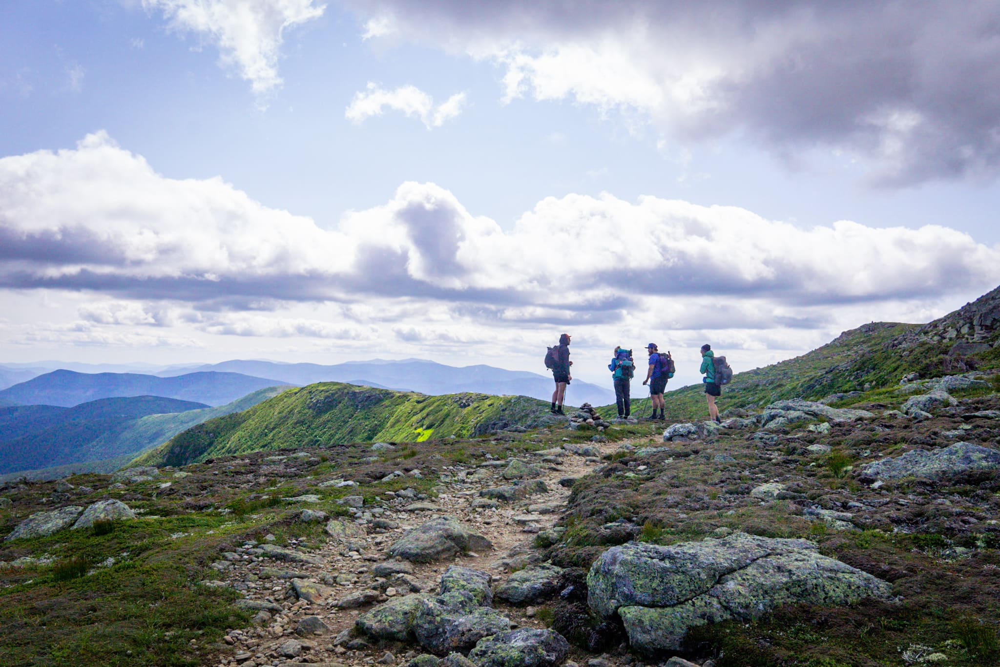
After a much needed day off at the Human Nature hostel, we left our heavy packs behind for the day, and knocked out another ten miles of rough terrain with tiny little day packs. While we still had to take our time, our knees and feet felt a world better for it.
Initially the plan was to return to the hostel after the ten miles, grab our packs and keep hiking – but rarely does the universe accept our plans. As we made our final descent down to the road, we could hear the low bellows of thunder from the cumulonimbus clouds that were quickly building. Humidity was up around 70% with a temperature in the high 80’s; This made for some very sweaty miles and great conditions for a storm.

By the time we reached the road it began to sprinkle. We tried our hand at hitchhiking, but it was difficult in the absence of cars. After an hour of waiting, the third car we’d seen picked us up and took us to the town of Andover. Still eight or nine miles from the hostel, here we at least had a store and covered porch to wait out the storm.
As the wind picked up and it really began to pour, we gave up on trying to hitchhike back to the hostel. We spent a good while talking with all the locals, and as the storm began to move on, we were able to catch a hiker shuttle back to our packs. At this point it was getting late in the day and there were no more shuttles going to the trail head. One more night at the hostel after all.
Most of the crowd that had shown up for the 4th of July had now moved on as well, which gave us an opportunity to really get to know the people behind Human Nature hostel. And as the sun began to sink below the passing storm, we were all blown away by the most beautiful sunset we have seen this season.

When morning came, we made our last round of goodbyes and headed back to the trail for good. On the way there, Yukon, our host, spotted a moose on the side of the road. We turned around to take a closer look, and slowly parked on the roadside. Trying to see if we could spot any others, we were surpised when a young calf suddenly stood up in the grass. By the time I grabbed my camera, they were gone.
As we started hiking again, the trail continued to rapidly climb and fall, but this only seemed to become more dramatic as the day progressed. As we summited the Baldplate mountains, we could see Old Speck mountain across the way, perhaps a couple miles as the crow flies. But a massive ravine known as Grafton notch stood between them, a sharp V cut into the land dropping several thousand feet.

So the rest of our day was spent crossing the notch and climbing up the other side. We found a nice camp on Speck Pond, high in moutains, and slept well with a cool mountain breeze.
The next day began early, and we began by dropping two very steep miles into the infamous Mahoosuc notch. A narrow canyon closed in on either side by vertical walls of granite, the notch is a one mile long garbled pit of giant mossy boulders. It has been referred to as, “The slowest or the funnest mile of the Appalachian trail.” I suppose that depends on your perspective.

Indeed it was a slow mile as we made our way through the massive jungle-gym. Eventually we arrived on the other side, thankful for the smaller tire sized boulders and rooted trail we have become so accustomed to.
After crossing the notch, we began another long climb up, where we summited several times before ultimately reaching the pinnacle of Goose Eye Mountain. From here, only a couple of summits remained before camp, but they at least got successively lower.

We called it an early day at the Carlo Col shelter, where we discovered several large youth groups had taken over all the camp sites. With this we were forced into the shelter. As soon as we approached, we could smell the fumes of fresh varnish radiating from the lean-to. Here we met Blitz, who works for the Appalachian Mountain Club, and she apologized for the smell as we thanked her for her service. We set up our sleeping bag by the entrance to the shelter in our attempt to mitigate the fumes, and thankfully we woke up without too much of a headache in the morning.
We woke up early along side our new southbound friend Wombat. An early riser as well, Wombat (from Australia) was up and out six. We followed about an hour behind, and began the daily ritual of climbing a few mountains.
Shortly after our departure, something surprising happened – we stumbled into New Hampshire! After 27 days and 300 miles, Maine is officially behind us!

Unsurprisingly, the condition of the trail did not dramatically change upon crossing the state line. We continued to rise and fall in the way that we have become accustomed to over the last few weeks. We did run into several northbounders who warned us that the trail ahead was slow going with boulders and roots. We did our best to hide our grins as we wished them the best of luck in Maine…
After our daily summits had been made, we began a long descent down to the Androscoggin river. Here we caught the highway by our thumbs and made a quick detour into the city of Gorham, New Hampshire. Being our first real city in nearly a month, it was a little overwhelming at first. With three hiker hostels, dozens of restaurants, and several grocery stores, it was hard to figure out where to even begin.

After a quick stop into the post office, we made our way across town to the Walmart. Being a few miles out of town, we thumbed a ride to the long awaited super center. Here we were quickly overwhelmed by the abundance of options; slowly weaving from one isle to the next. We quickly accumulated way too much food and headed for checkout.
It took us close to an hour sitting outside of Walmart to get all of our food sorted. After consuming as much as we could in an effort to fit our resupply back into packs, which didn’t work, we walked back to the road, grocery bags in hand, and tried to catch a ride back into the heart of town.
After fifteen minutes of unsuccessful hitching, we were approached by the shuttle for the Rattle River Hostel back in town. A jovial woman introduced herself as Pelican, and said that she was picking up a bunch of hikers, but she thought she could squeeze us in. Before we knew what was happening, we were cramming 15 hikers into the glorified van.
We soon arrived back at the Rattle River Hostel, where we were given free acess to the wifi and picnic tables. As we got to talking, one thing led to another and we ended up with a work-for-stay, legally a “Cultural exchange,” for a couple nights at the hostel. This was particularly timely as a cold front was moving in, bringing rain and lightning to the high peaks that lie ahead.

Our chores at the hostel were straight forward, and we soon found ourselves doing a little extra to pass the time. I was given access to the wood pile with an axe, and had a ball. We made pancakes and coffee in the morning for guests and made many great connections along the way.
Our anticipated storm came and went, but we were very much enjoying our accommodations and company at the hostel. With this, we decided to stay another day, and the folks at Rattle River slack packed us through the first section of the white mountains – the Wildcat range. In essence, we left the majority of our gear at the hostel, packed a few snacks for the day, and got dropped off 21 miles (by trail) to the south.
Without the burden of our packs, we flew up the wildcat mountains, all five of them. The initial climb was the longest, but once we climbed it we did a fair amount of ridge walking. After the wildcats came the Carter Peaks and Mount Moriah. It was a long day but after 21 miles we walked right back to the hostel and enjoyed one last night with our new friends.

We made one last breakfast, special with blueberries and scrambled eggs, for everyone at the hostel. We went through a 10lb bag of Krusteaz without much difficulty. After cleaning up and getting our things together, we parted ways and went back to the trail.
As we approached the trailhead by car, we were optimistic that the clouds hanging out atop the peaks were clearing out and making way for a clear blue sky. But as we began to hike, the clouds only seemed to coalesce and darken above us.
After a long climb, we came out on an exposed ridgeline leading up to our first peak in the presidential range – Mt. Madison. Just before we reached the summit, we could see a wall of water quickly approaching from the west. We threw off our packs and weilded our rain gear. Soon the rain began to pelt us, and the hard wind turned freezing through our saturated clothes.

Thankfully one of the great features of the white moutains, of which the presidential range is one part, are the huts. Every five to eight miles, each hut is a beautifully rustic cabin, powered by wind and solar, furnished with dorms and a small cafeteria. Breakfast and dinner are served daily, and baked goods can be purchased throughout the day.
Back to our freezing situation on Mt. Madison; upon arriving on the summit, the inhospitable weather forced us down the other side where the Madison hut lay less than a half mile away. Much to our dismay we got stuck behind a large group of day hikers who moved with the speed of molasses. After the slowest half mile in human history, we made it to the hut.

After sitting inside and slowly warming our bones, we worked out a work trade agreement with the folks who ran the hut. As camping is tightly regimented in the white mountains and a stay at the hut is well over $100/ person, work-for-stay is common for thru-hikers. As an added bonus you get to finsh off the leftovers after the meal is served.
After awkwardly standing in the corner watching everyone eat, the staff cleaned everything up, we were invited to eat. After filling our stomachs beyond capacity with real food and fresh ingredients, we spent an hour wiping down all the shelves with a bleach rag and cleaning the stove. Then it was another awkward bit of standing in the corner as we waited for the guests to go to bed so we could sleep on the floor of the mess hall.
All things considered the food was great and the company was awkard. But as we slept we could hear the wind roaring outside and this made the ordeal worth it. In the morning the staff shared with us that they recorded eighty mph gusts overnight.
Even after the sun came up, the wind was still whistling and we were surrounded by those misty clouds. The staff offered us breakfast, and after a quick look outside, we decided we weren’t in a big a rush to leave.

By nine we got the train moving, and every once in a while the clouds would break long enough to reveal the moutains and gulfs that encompassed us. From Madison hut we continued to climb towards the tallest peak in New England – Mt. Washington. Notorious for bad weather and high winds, it is also filled with tourists, as there is both a road and cog-railway that lead to the summit.

We arrived at the top much faster than anticipated, largely because we were able to ridge walk from Madison without losing too much of our hard earned elevation. The views here were largely non-existant thanks to the clouds, but we stopped into the snack bar and mailed a few postcards while we were there.
Leaving the overwhelming scene behind, we skipped down the other side of the mountain on some of the best trails we’ve seen in 300 miles. It didn’t take long before we arrived at the lake of the clouds hut; thankfully it was much quieter here. As we walked inside, we were surprised to find several of our southbound companions setting up a game of Catan. We eagerly jumped in and played the most scenic game to date.

After a quick victory, we got our things together and headed outside. Here we bumped into Styles, whom we met in Virgina at trail-days and shares close mutual friends. Styles and his friend Wankles were finishing the Cohos trail, which overlaps the Appalachian trail in the White mountains. Excited at the reunion, we all took off down the trail together.
About this time the conditions really started improving, with the passing of dramatic clouds that only intensified the grandeur of the peaks. The ridge walk down from the Lake of the Clouds was one of the best to date, revealing expansive views of the presidential range as we were primarily above treeline.

After a couple of the best hours we’ve had on trail, we came into Mizpah hut, where the majority of our party called it a day and secured work-for-stay. With Styles and Wankles, we decided to push a little further given the conditions, and headed for Webster cliffs.
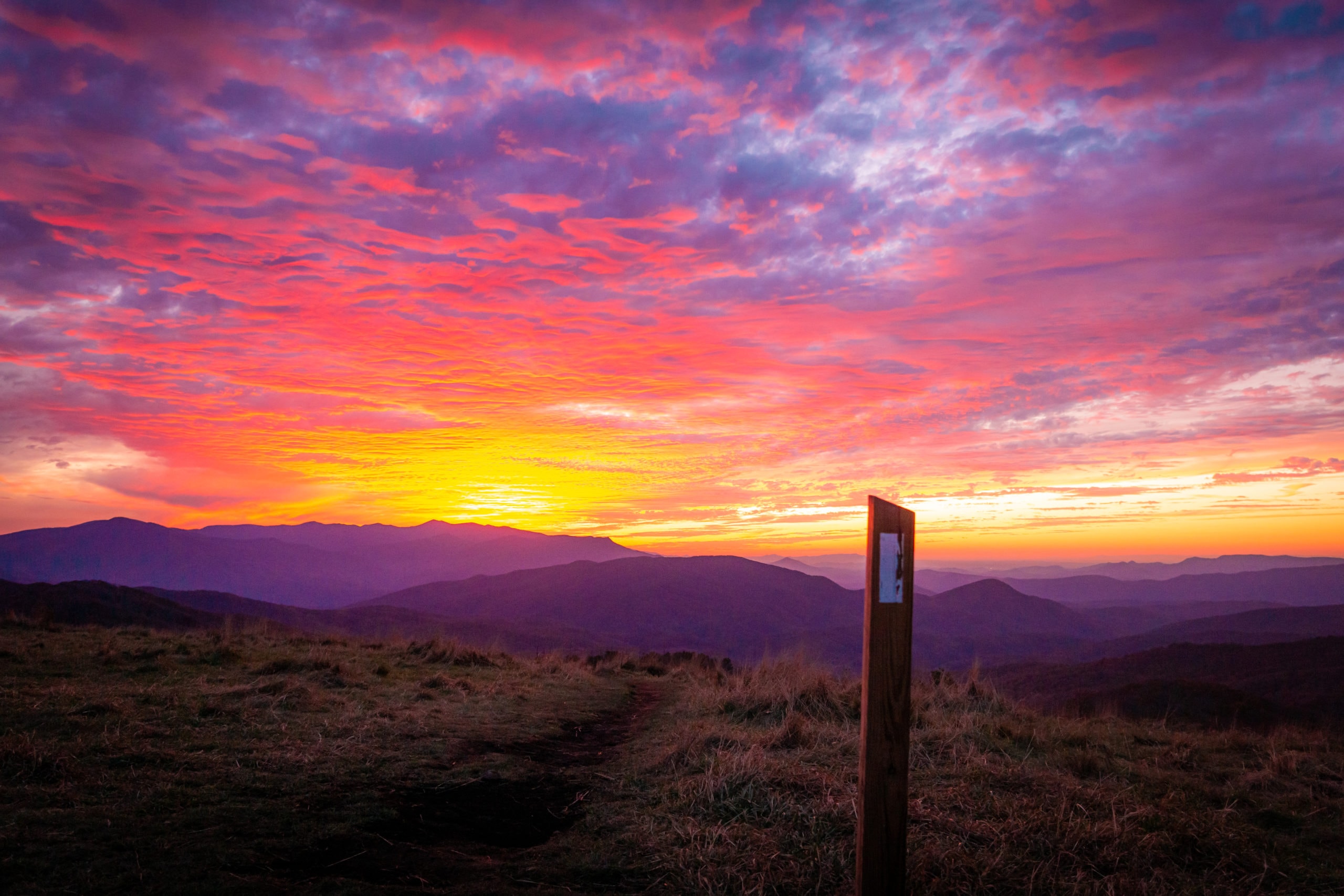
We found a secret camp with exceptional views looking down into Crawford Notch. After setting up camp, we enjoyed dinner and tea on the cliffs and watched the sunset before bidding the day adieu.

In the morning it was a short hike down to the road, where Styles and Wankles finished their 200 mile trail and said farewell. We climbed steeply up the ravine on the opposite side, and began the trek up to Mt. Garfield and Franconia Ridge.
We hit the Zeeland Hut in the afternoon, and stopped in for some fresh baked goods. As we did, the grey skies began to drizzle, tempting us to stay at the hut. But in the interest of moving along, we hiked out, and almost immediately the clouds seemed to dissipate. We made good time to Guyot Shelter, but were a little dismayed when we discovered it was a almost a mile off trail. Above treeline without water or any other options, we hiked down to Guyot and called it a day.
Despite the forecast calling for evening showers, we stayed dry and awoke to a beautiful sunrise. Assuming the rain would come eventually, we packed up camp and hit the trail early.
We got about twenty minutes of dry hiking before it began to lightly rain. Soon a light rain turned into a heavy one, but we pushed on until we hit the Garfield Ridge Shelter, just above 4000ft and just below treeline.
We arrived soaking, and quickly stripped off the wet clothes for the dry wool ones hidden deep in our packs. With five miles of exposed ridge walking ahead, we decided to call it an early day and wait until the risk of thunderstorms had passed.
We opened our eyes the next day to find the sun burning like an orange ember on the horizon surrounded by the purple-blue hue of a cloudless sky. Excited for our hike down the exposed ridgeline, we packed up and hiked out as quickly as we could.

After a steep hike up, we summited Mt. Garfield. The clouds began to move back in, but we were able to still catch some good views standing on the foundation of an old fire tower that once lived there.

As we dropped down from Garfield, the clouds thickened. Approaching Mt. Lafayette, one of the more prominient peaks in the range, we became skeptical that we would get any views at all. But similar to the day we hiked across Mt. Washington, the boiling columns of clouds cleared just enough to reveal the full scope of the surrounding mountain fortress.

Our ridge walk down from Lafayette to Mt. Lincoln and Liberty was truely spectacular. Vindicating our decision to wait out the storm, the views from that ridge line gave one the feeling that they were living in a majestic cloud kingdom. But as all things go, we eventually descended and left that other world behind. We came down to Franconia Notch, where we rode the highway into the town of Lincoln and the Notch Hostel.
With just a small section of the White mountains left to hike, we are taking our time in the Northeast. Soon the trail will present less daily challenges, and we hope to pick up the pace when that happens. Onto Vermont!
Cheers from the trail!
Stump & Mandalynn
